The perched villages of the Avance
80 km / 2h drive (without stopover)
By car, by motorcycle... Crisscross the Avance Valley and its small country roads along our villages nestled at the border of the Gapençais, the foothills of the Piolit and the Champsaur. Unsuspected panoramas and real hidden treasures that will surprise you!
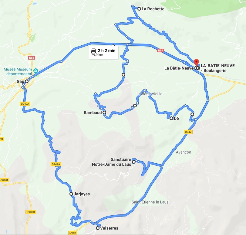
START, La Bâtie-Neuve (center)
LA BATIE-NEUVE go up towards the Col de Manse via the D14 to La Rochette.
LA ROCHETTE you can get as close as possible to the Napoleon's hat which dominates the valley, recognizable by its shape identical to the hat of the Emperor Napoleon Bonaparte. Park at hameau des Guérins, near the information panel.
RAMBAUD go back down to Rambaud on the D314. Cross the RN94 to take the direction of Grand Larra then La Moutouse and finally Rambaud. Charming small village of average mountain, Rambaud attracts all the glances thanks to its small bell-tower which overhangs it. It is a small paradise of nature known for its pedestrian paths in balcony "Le Serre du Clocher. From this astonishing white bell tower and its orientation table, the view is impregnable, 360° on the Gapençais, the Champsaur and the Val d'Avance to the walker.
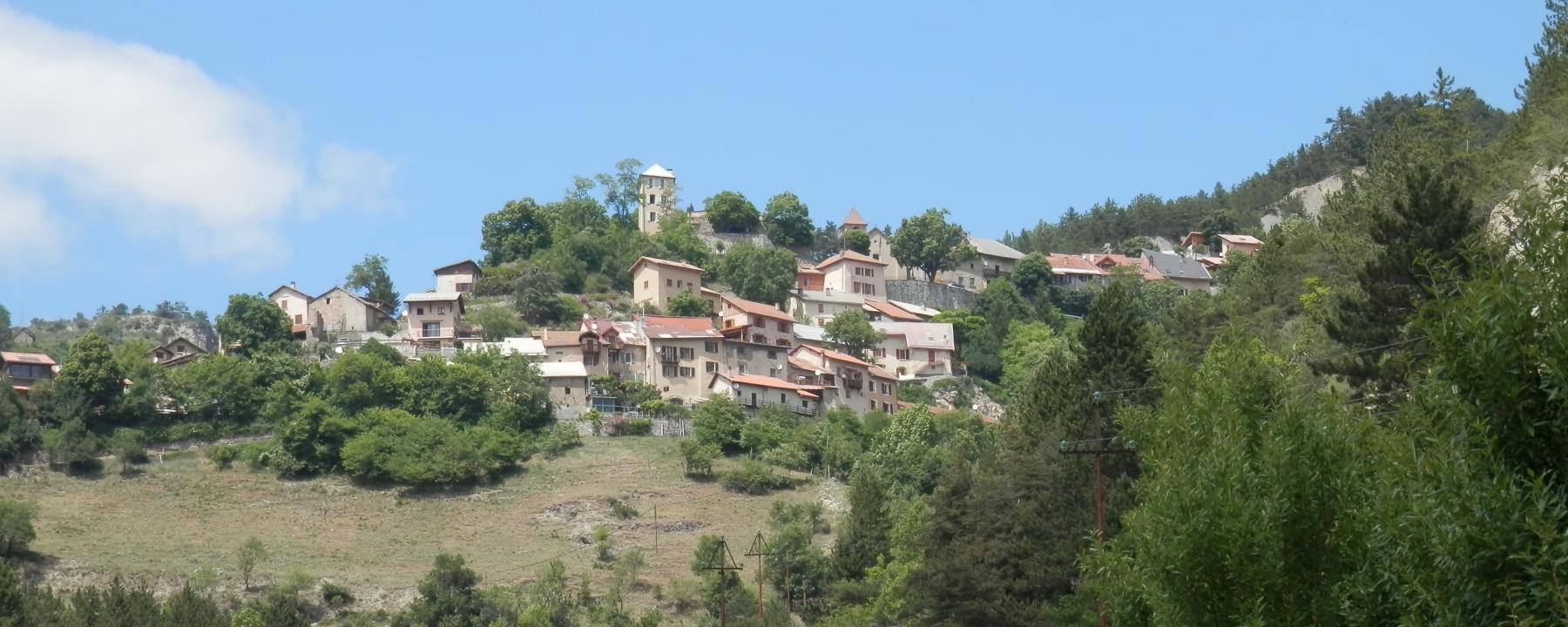
LA BATIE-VIEILLE from here, take the Bois Vescal road in the direction of La Bâtie-Vieille. 360° view on the Gapençais, the Champsaur and the Avance guaranteed! From the top of its hill, a watchtower of the XIIth century stands over the village. For history lovers, take the historical path which marks out the small village.
- SAINT-ÉTIENNE-LE-LAUS take the D942 through the hamlet of Santons in the direction of Saint-Etienne-le-Laus. The village, a place of pilgrimage, is home to the Sanctuary of Notre-Dame-du-Laus. To get there, take the D111 road where you can discover this spiritual site, one of the most visited in the department. On the spot: the house where Benoîte Rencurel was born (shepherdess who would have seen the apparition of the Virgin Mary), the Chapel of the Precious Blood, the Pindreau monument... Stop and lunch at the Notre-Dame-du-Laus hostelry recommended !
- VALSERRES vALSERRES : you are in the heart of the Avance valley. Cradled by the culture of the vine, this village shelters the Cave des Hautes-Vignesthe only wine cooperative in the department. On foot, in the village center, along the streets, discover the parish church, the castle, the Saint-Maurice chapel, the old wash house, the fountain of the Prêtes... View on the vineyards and the mountain Sainte-Maurice which dominates.
- Jarjayes / Gap : from Valserres, go up by the D942A to Jarjayes by the Col de la Sentinelle. Balcony road and winding! Splendid view. You will arrive in Gap. From Gap return to La Bâtie-Neuve or prolong the pleasure by visiting the Sweet Capital!
ARRIVAL, in La Bâtie-Neuve (center)


The panoramas of the Durance
48 km / 1h45 of road (without stopover)
Eight of our villages are perched on the banks of the wildest alpine river. From Espinasses to Venterol, it is also the cradle of the Route des Fruits et des Vins, bordered by the Curbans canal which carries the waters of the Durance.
START, Rousset - Rousset Tourist Office / D55

ROUSSET / ESPINASSES the Canal de la Durance runs through the valley. It is a canal for irrigation, drinking water supply and electricity production built by EDF to divert part of the waters of the Durance. Built between 1963 and 1965, the canal of Curbans is the part of the factory canal which conveys the waters of the Durance from the dam of Espinasses to the power station of Curbans during 5 km. At its eastern end, the canal receives the waters of the compensation lake of Espinasses, at the foot of the dam.
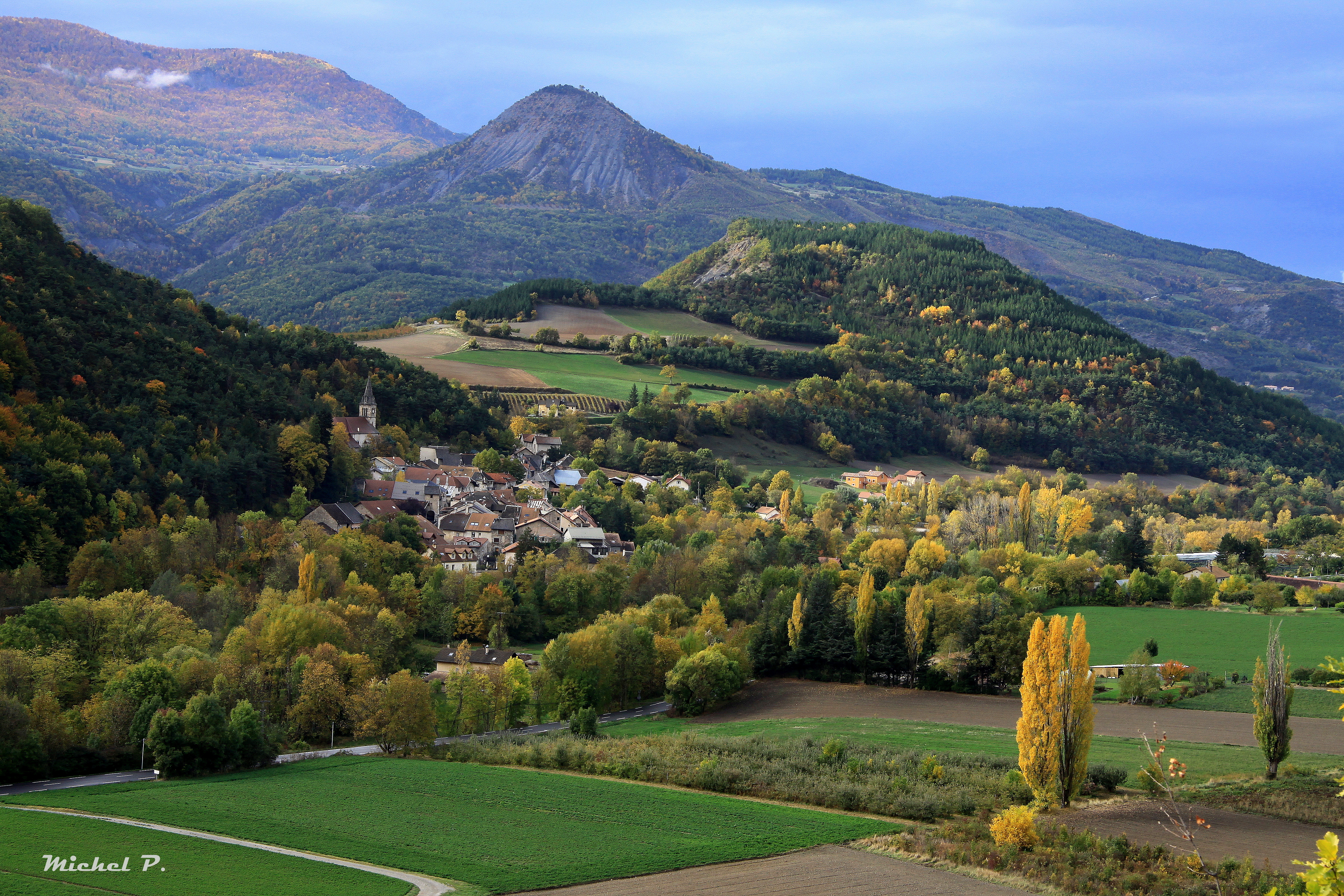
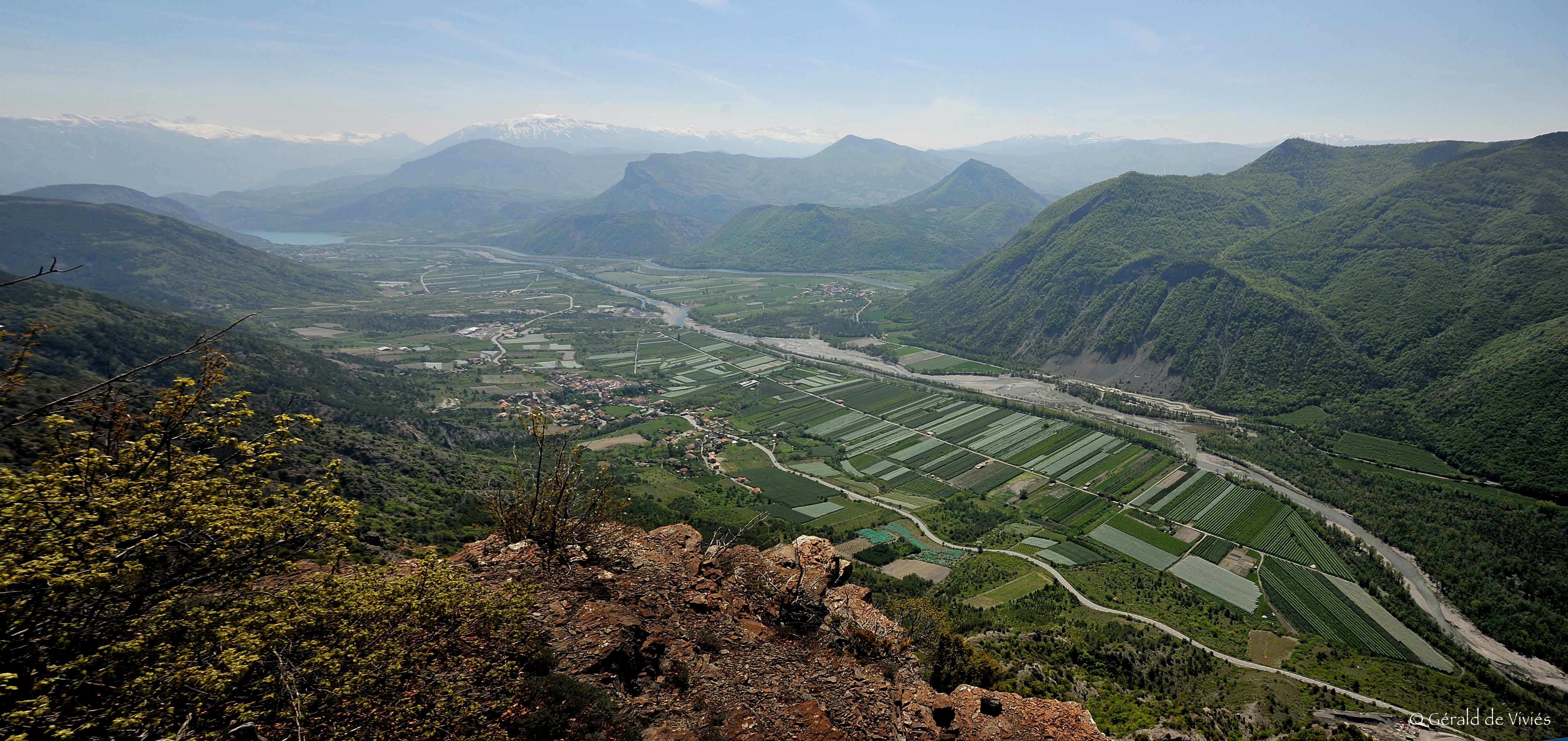
- THÉUS be careful with the winding road! The continuation of your discovery, continues on the D53, in height, in the village of Théus and on the slopes of Mont-Colombis. This village offers one of the most beautiful panoramic views of the Durance valley. During your stop, you will discover : the castle (in ruins), dominating the village. The base of the rampart now surrounds the communal cemetery and the parish church of Saint-Nicolas. Continue your walk by going up the D53 towards the The "Demoiselles Coiffées de Théus (classified geological site) where a magnificent panorama awaits you to admire them. The terraces of the Demoiselles, a space fitted out with a picnic area and deckchairs will be the occasion for a contemplative break. Pfew more kilometers and you will arrive at Mont-Colombisa summit rising to 1 734m of altitude, with a 360° panorama on the lake of Serre Ponçon, the valley of the Durance and the Ubaye. An orientation table at the top will allow you to spot the biggest summits of the Hautes-Alpes. This classified and secret natural site, to breathe & take height! On the way down you will see the Saint-Pierre chapel. Make a small stop at the new restaurant Le Balcon de Théus to eat or have a drink on their superb terrace with a view on the Durance valley.
- ROCHEBRUNE go back down to take the D56 along the Durance to the Base de loisirs Les 3 Lacsan obligatory break to refresh yourself and dip your feet in one of the 3 lakes or in the Durance which border them!
-
PIÉGUT & VENTEROL : continue your walk along the Durance on the D56 towards the villages of Piégut and Venterol, these more outlying villages, facing each other like sisters, seduce by their quietness. Perched on the hill, they offer a breathtaking view of the Durance valley and its immense fruit orchards. The bottom of the valley is home to the famous production of apples, pears, peaches, apricots... all along your route you will find local producers (Route des Fruits & des Vins). When you arrive in Piégut you will discover the Saint-Colomban church, of archaic architecture built in the XVIIe century. On the commune of Venterol you will observe theon the commune of Venterol you will observe the church of Saints-Crépin-et-Crépinien which has been rebuilt but also the ruins of the fortified castle of Venterol known as Château Ratier, the old parish church of Urtis, the castle of Urtis, the church of Saint-Jean-Baptiste in the village of Tourniaires.
-
REMOLLON: from Venterol and the D854, go back down on the D900B, cross the Durance in the direction of Remollon. This is a recommended stop because of its beautiful architectural heritage, with the village and its narrow and steep streets, old armorial doors, the Saint Roch chapel dominating the orchards from its rocky peak and its 16th century bell tower. To finish this day : a stop at the petrifying waterfall! On foot, in 5 minutes from the D900B, go down the path of the waterfall to the footbridge.
ARRIVAL, Rousset - Rousset Tourist Office / D55


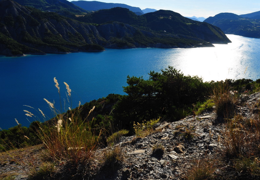
Around the Serre-Ponçon Lake, from the Durance to the Ubaye
80 km - 1h50 of road (without stopover)
For one day, follow a loop from Rousset to Savines le Lac around the Serre-Ponçon Lake, with its different viewpoints, all equally majestic!

START, Rousset - Rousset Tourist Office / D3
- LA BRÉOLE take the D900B in the direction of Ubaye, Barcellonnette, la Bréole. First stop at the belvedere of the Sardanne.
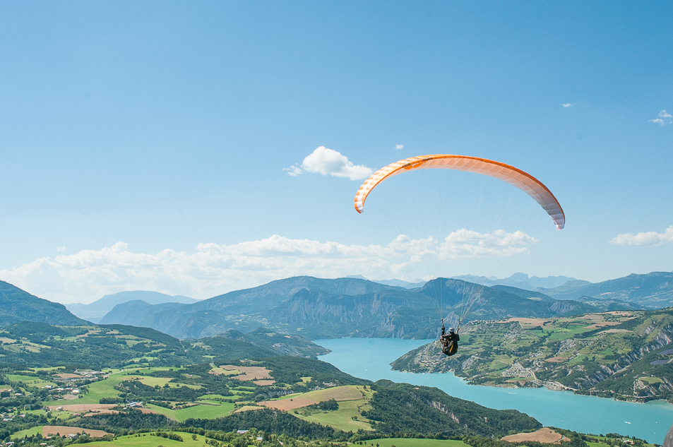
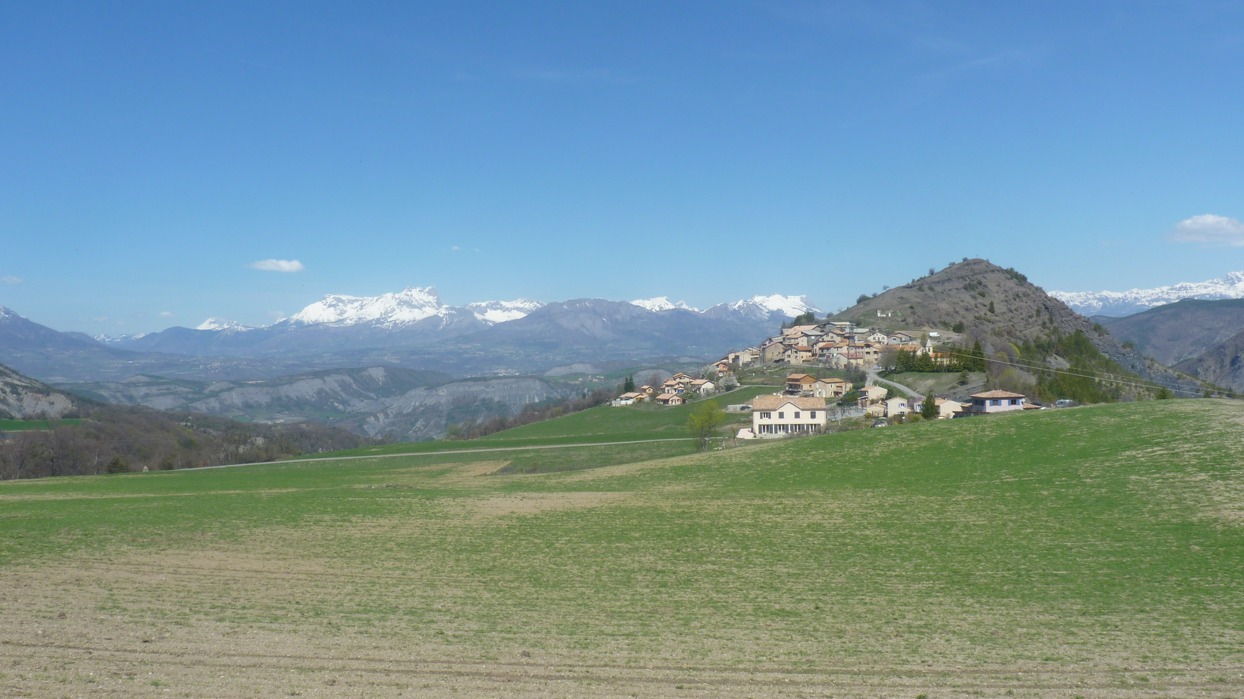
- SAINT-VINCENT LES FORTS saint-Vincent les Forts : the village located on the side of a rocky spur offers a grandiose landscape. Known for its fort, Saint-Vincent watches over the Ubaye valley. High site of paragliding, take the time to admire its "voltigeurs" in the sky, a magnificent spectacle. Go up to the Tower and the Vauban Fort to contemplate the colors of the lake. Beach of Saint-Vincent les Forts to discover!
To reach your third stopover, you will drive along the D954 road overlooking the lake with its mountain curves that will make you take height for the greatest pleasure of the eyes.
-
LE SAUZE DU LAC: at the crossroads of the Ubaye and the Durance, this small village offers one of the most beautiful views of the Hautes-Alpes. The village of Sauze-du-Lac has a public beach Port Saint-Pierre at 780 meters below.
-
SAVINES LE LAC: famous seaside resort and famous for its bridge, at the foot of the Grand Morgon and the forest of Boscodon. A new town, it represents the new era of the territory and of the Serre Ponçon Lake. Two public beaches to discover as well.
-
CHORGES : as you drive towards Chorges, contemplate the turquoise waters until you find the small Saint-Michel Chapel, emblem and souvenir of the region in memory of the sunken villages. In Chorges, the bay of Saint-Michel and the bay of Chanteloube are two jewels of the lake, very popular with bathers.
-
A little more? Before returning to Rousset via the Col Lebraut, the most courageous can make a detour to Saint-Apollinaire! Going up towards Réallon from Chorges. Its dominant, unusual and discreet position is the most sought after. A haven of peace which offers one of the most beautiful panoramas on the lake. To make at the end of the day, for the beautiful colors of the evening...
ARRIVAL, Rousset - Tourist Office of Rousset / D3