

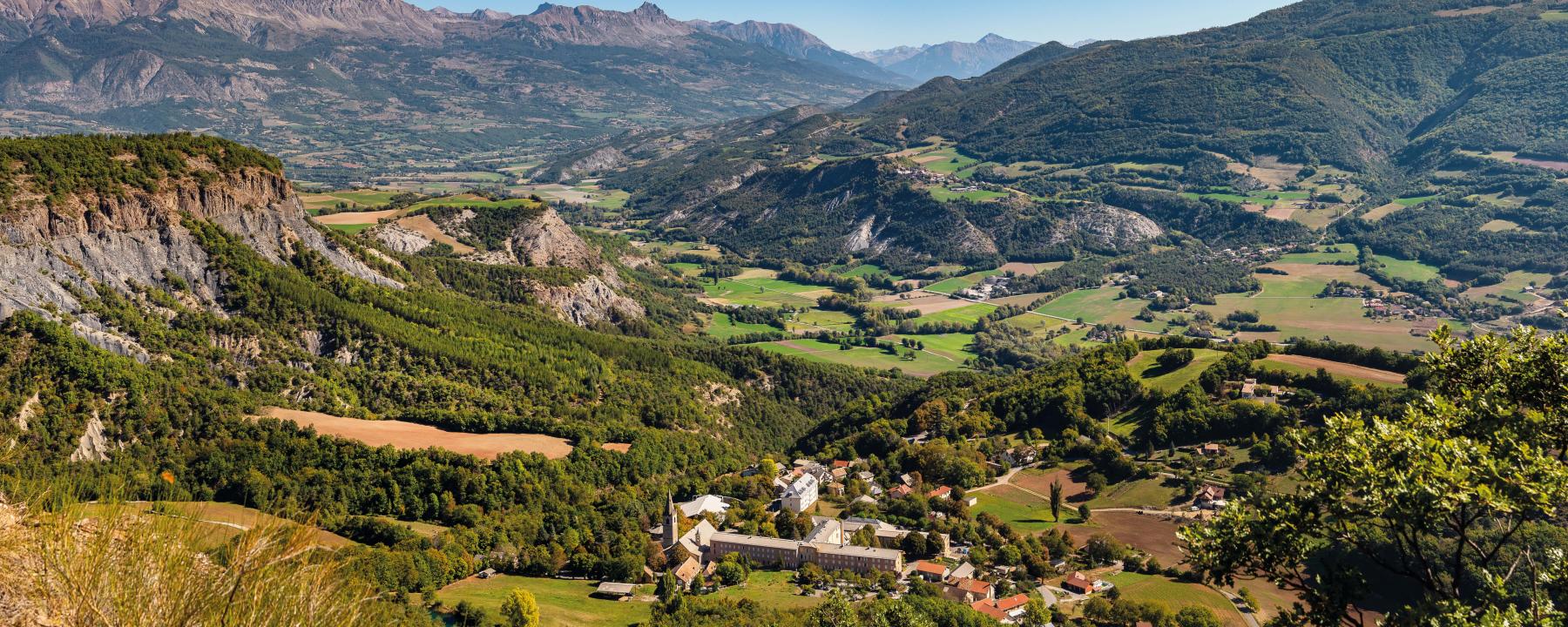
The Durance Valley
Land of water and fruits
8 villages :
Bréziers, Espinasses, Piégut, Remollon Rochebrune, Rousset-Serre-Ponçon, Théüs and Venterol
The Durance Valley is a land where the genius of man has mastered the tumultuous and devastating waters of a wild Durance thanks to the construction of the famous Serre-Ponçon dam.
Wild and intrepid... the Durance is thelifeblood of the Hautes-Alpes! Eight of our villages are perched on the banks of the wildest of Alpine rivers. From Espinasses to Venterol, it's also the cradle of the Route des Fruits et des Vins.
The Durance river rises at Montgenèvre, at an altitude of 2,300 metres, and continues for over 300 kilometers to flow into the Rhône. The Durance is the lifeblood of the region, irrigating farmland, generating hydroelectric power and offering sumptuous sites for bathing and white-water activities. A generous, protected natural environment, classified as a Natura 2000 site along its entire length.
The region boasts a generous, protected natural environment that remains a major attraction for all visitors: pure air, crystal-clear waters, exceptional panoramas and landscapes. It's also the cradle of a production renowned for its sweet fruit, apples and pears, and its delicious wines. All along the Durance, producers invite you to visit and sell their produce.
Agriculture, and more particularly arboriculture, has taken over the land at the bottom of the valley, leaving the towns and villages to settle in the heights.
In addition to the beaches of Lac de Serre-Ponçon, you'll find wild shores for those who want to get away from it all, as well as canoeing, kayaking and fishing.
The valley is crossed by the Canal de la Durance, an irrigation, drinking water supply and electricity production canal built by Électricité de France to divert part of the waters of the Durance. Built between 1963 and 1965, the Canal de Curbans is the part of the factory canal that carries the waters of the Durance from the Espinasses dam to the Curbans power station over a length of 5 km. At its eastern end, the canal receives water from the Espinasses compensation lake, at the foot of the Serre-Ponçon dam.
Your prescription for a great vacation!
- Lying on the beach of Bois-Vieux and immersing yourself in the floating pool
- Go down the Durance river in a canoe
- Take a walk close to the "Demoiselles coiffées
- Visit the lookout of the dam and the hydro-electric plant
- Go up to the Mont-Colombis and its 360° panorama on the Hautes-Alpes
- Take the Route des Fruits et des Vins and taste the local products at the producers
- Try the accrobranche and the paintball at the site of the 3 lakes of Rochebrune
- Try wakeboarding, stand-up paddle or water skiing
- Spend the evening on the terrace with a breathtaking view
- Test the patience of the fish on the banks of the 3 lakes and the Durance
- Take a "boat selfie" on the lake of Serre-Ponçon...
The Val d'Avance
Take the key to the fields
8 villages:
Avançon, La Bâtie-Neuve, La Bâtie-Vieille, La Rochette, Montgardin, Rambaud, Saint-Etienne-Le-Laus and Valserres
The Vallée de L'Avance is located in the Hautes-Alpes between the Durance Valley, the Serre-Ponçon lake and the town of Gap. It is bordered by the Piolit-Chabrières massif and the Durance canal on the Serre-Ponçon side.
Situated in the heart of the Hautes-Alpes department, the Avance ranges in altitude from 600 m to almost 2,500 m, dominated by the Piolit peak, a Natura 2000 site. The river Avance, a tributary of the Durance, flows through the area, confluencing between Remollon and Lettret.
The Avance is easily identifiable by the Puy-Maurel, which dominates it, and its antenna, visible from afar.
The two agricultural valleys, the Vallée de l'Avance and the Vallée de la Durance on the Lac de Serre-Ponçon side, unite around Mont-Colombis, whose slopes lie between the communes of Espinasses, Théus, Remollon, Valserres, Saint-Étienne-le-Laus, Avançon, Montgardin and Rousset-Serre-Ponçon.
The Avance valley is home to the sanctuary of Notre-Dame-du-Laus, the most visited site in the Hautes-Alpes. With almost 40% forested area, this is a land that invites you to take to the fields, between green hills and mid-mountains, where the colors of sun, earth and water mingle!
Every village is perched on a hilltop, offering breathtaking panoramic views! The balconies of Rambaud, the promontory of Avançon, the historic trail of La Bâtie-Vieille, the heights of La Bâtie-Neuve... There are so many secrets and landscapes to discover here.
Your prescription for a good vacation!
- Crapahuter to the Pic du Piolit
- Discover the balcony trails from Rambaud to Bâtie-Vieille
- Do the Tour de l'Avance on horseback
- Discover the Notre-Dame-du-Laus sanctuary
- Go to a village festival and dance the night away
- Visit the vineyards of Valserres and take a break for wine tasting at the Cave coopérative
- Take pictures of the Avance river from the Chapeau de Napoléon
- Go up to the promontories of Avançon and Montgardin
- Ride a mountain bike to the Puy Maurel !