


A real sporting challenge, reaching Mont Colombis from the village of Avançon allows you to fully appreciate this emblematic summit, as well as the grandiose panoramas it offers!
Start / Finish : Avançon
Communes crossed : AVANCON, THEUS, ESPINASSES
The route starts in the centre of the village of Avançon, on the church square opposite the fountain. Take the road that climbs on the left towards the Forest de Borel. Pass near the Notre-Dame-de-Pitié chapel then continue straight on the track to reach a crossroads.
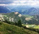
VIEWPOINT - Enjoy the panorama of the Puy Maurel mountain to the west (telecom tower), the Pic de Bure (2,709 m), the Vieux-Chaillol (3,163 m) and the Piolit (2,464) to the north. Turn right towards Mont Colombis and climb a forest track lined with deciduous trees for about 500 m. At the first right-hand bend, leave it for another track on the left. VIEWPOINT - Walk along the cultivated fields and admire the view once more before entering the forest
Continue right on a nice path rising towards the Forest de Charpin. The climb is through a thick deciduous forest.
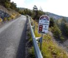
This path leads to a tarmac road. Take it to the right, then only 50 metres further on, turn left and cross the barrier to continue on a forest track. Continue to climb through this pretty mixed forest, composed of beech, fir, larch and Scots pine among others; cross the valley and follow the track to the place called Forest de Charpin.
From the crossroads of Forest de Charpin take the track on the right following the direction of Maugarot. The path is in the Avançon forest. The track crosses high voltage lines twice. At the next intersection, turn left onto the ascending track towards Mont Colombis and the Demoiselles Coiffées. Gradually leave the forest for the world of the mountain pastures and enjoy the clear view to the west again.
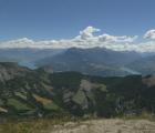
Continue towards Mont Colombis on this track, keeping straight on. Take advantage of this cross-country path to enjoy the view of the Ceüse mountain, a world-renowned climbing spot.
Once you reach the road, turn left and follow it to reach the Chapelle des Bergers. This asphalt section nevertheless offers a view of the Vallauria valley and its Demoiselles coiffées.
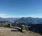
At the Chapelle des Bergers, climb the last few metres on the asphalt road to reach Mont Colombis. Opposite the telecom tower, turn left to reach the summit.
VIEWPOINT - Enjoy the panorama of the Serre-Ponçon lake, the Ubaye and Durance valleys. Take a well-deserved rest before tackling the descent. Descend by the same path to the Chapelle des Bergers. From there, take the track on the right. The path gradually leaves the mountain pastures for the forest. The views to the north open up again. After about 3.5 km, reach La Croix des Prés and its Resistance monument. Continue to the left towards Forest de Charpin to recover the original undergrowth path. The return to the starting point is via the latter.
All year round.
Subject to favorable snow and weather conditions.

